Indonesia expands danger zone as Mount Lewotobi erupts again
text_fieldsJakarta: Indonesia’s Centre for Volcanology and Geological Hazard Mitigation has raised the alert status of Mount Lewotobi in East Nusa Tenggara Province following a series of volcanic eruptions, prompting the expansion of the designated danger zone around the volcano.
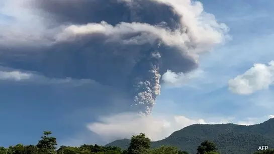
The alert was heightened on Sunday night after multiple eruptions, the most powerful of which sent an ash column soaring 6 kilometres into the atmosphere. In response, authorities extended the exclusion zone from 6 to 7 kilometres for areas located to the northwest, north, and northeast of the crater. In all other directions, the original 6-kilometre restriction remains in effect.
On Monday, Mount Lewotobi erupted again at 15:47 local time, releasing a thick grey ash plume that rose 5 kilometres into the sky and drifted north and northwest.
The Volcano Observatory Notice for Aviation (VONA) continues to issue a red-level alert, the highest warning tier, indicating a significant threat to aviation. Flights are prohibited below 6 kilometres in the vicinity of the volcano due to the risk of ash clouds, which can damage aircraft engines and reduce visibility.
Authorities have strictly prohibited all activities within the expanded 7-kilometre radius in the west, north, and northeast sectors of the crater. Communities, tourists, and visitors are urged to stay away from these high-risk zones.
Residents living near the volcano are also being cautioned about potential lava floods (lahars), especially during heavy rainfall. Such floods can occur along rivers that originate from the summit of Mount Lewotobi. In ash-affected areas, people are advised to use face masks or nose coverings to protect against inhalation of volcanic ash.
Last month, similar warnings were issued when Mount Lewotobi released an ash plume up to 3,500 metres high. On April 16, the Volcanology Centre advised residents to remain alert to the risk of lava floods during heavy rains. An earlier eruption on March 20 produced an ash column reaching 8,000 metres, underscoring the volcano’s volatile nature.
Standing at 1,584 metres, Mount Lewotobi is among Indonesia’s 127 active volcanoes. The country, home to 270 million people, lies within the Ring of Fire—a seismically active belt encircling the Pacific Ocean known for frequent earthquakes and volcanic eruptions.
Indonesia sits atop the converging boundaries of the Eurasian, Australian, and Pacific tectonic plates, making it one of the most volcanically active regions on Earth. The nation has witnessed several of history’s most powerful eruptions, including the catastrophic 1815 eruption of Mount Tambora, which remains one of the deadliest ever recorded.
With IANS inputs


