ISRO-NASA’s $1.5 billion NISAR satellite successfully launched
text_fields

New Delhi: Marking a major milestone in India-US space cooperation, the NASA-ISRO Synthetic Aperture Radar (NISAR) satellite was successfully launched on Thursday. The mission, valued at $1.5 billion, is the first joint Earth observation initiative between the two space agencies and aims to revolutionise environmental monitoring and disaster management across the globe.
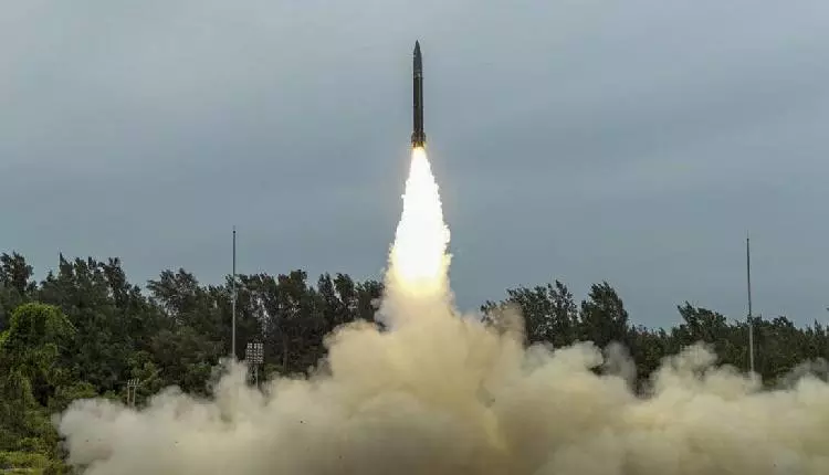
The NISAR satellite lifted off aboard India’s GSLV-F16 rocket at 5:40 p.m. from the Satish Dhawan Space Centre in Sriharikota, Andhra Pradesh. About 19 minutes after liftoff, the rocket is set to place the satellite into a 743-kilometre sun-synchronous orbit, the first time a Geosynchronous Satellite Launch Vehicle has been deployed for such an orbit.
“We have liftoff! GSLV-F16 has successfully launched with NISAR onboard,” announced the Indian Space Research Organisation (ISRO) in a post on X. Union Minister of State for Science and Technology, Jitendra Singh, also shared the moment, writing, "#GSLV-F16 lifts off with the NASA–#ISRO NISAR Earth Observation Satellite."
The successful launch highlights the growing strength of India-US relations in space exploration. Following the bilateral summit between Prime Minister Narendra Modi and US President Donald Trump in Washington, D.C., earlier this year, both leaders declared 2025 as a landmark year for US-India civil space cooperation.
Developed jointly by NASA and ISRO, the 2,392-kg satellite will scan Earth’s landmass and ice-covered regions every 12 days, delivering high-resolution imagery across a 242-kilometre swath using SweepSAR technology. NISAR is the first satellite to employ dual-frequency Synthetic Aperture Radar (SAR), carrying both L-band and S-band radars.

NASA contributed the L-band SAR system, including a high-rate telecommunication subsystem, GPS receivers, and a 12-metre deployable unfurlable mesh antenna. ISRO developed the S-band SAR payload, the I-3K satellite bus to support both radars, the GSLV-F16 launch vehicle, and all associated launch services. Together, the two radar systems are mounted on NASA’s 12-metre reflector antenna, hosted by ISRO’s customised satellite platform.
NISAR is designed to capture 24/7 imagery regardless of weather or lighting conditions. "It can take pictures of the Earth 24 hours a day in all weather conditions. The satellite can detect landslides, aid in disaster management, and monitor climate change,” said ISRO Chairman Dr. V. Narayanan.
The satellite will monitor subtle surface movements and crustal deformations, helping scientists detect and assess natural hazards such as earthquakes, tsunamis, volcanic eruptions, and landslides. It will also be used for sea ice classification, storm tracking, shoreline monitoring, ship detection, soil moisture changes, and crop mapping.
"Go NISAR! The joint NASA-India satellite aboard @ISRO's Geosynchronous Launch Vehicle launched from the southeast Indian coast at 8:10am ET (1210 UTC) on its mission to monitor Earth's changing land and ice surfaces," NASA posted on X.
With NISAR, India and the US are poised to set new standards in environmental observation and Earth science, strengthening not only scientific collaboration but also resilience in the face of climate change and natural disasters.
With IANS inputs